
Thank you for supporting this site ❤️
Make a donation
Make a donation
Gear up for your next adventure:
As an Amazon Associate, this site earns from qualifying purchases at no extra cost to you.
Gargunnock topographic map
Click on the map to display elevation.
Thank you for supporting this site ❤️
Make a donation
Make a donation
Gear up for your next adventure:
As an Amazon Associate, this site earns from qualifying purchases at no extra cost to you.
About this map
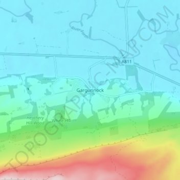
Name: Gargunnock topographic map, elevation, terrain.
Location: Gargunnock, Stirling, Scotland, FK8 3BH, United Kingdom (56.10445 -4.10283 56.14445 -4.06283)
Average elevation: 94 m
Minimum elevation: 3 m
Maximum elevation: 434 m
Thank you for supporting this site ❤️
Make a donation
Make a donation
Gear up for your next adventure:
🧭Global Orienteering Compass - High-precision liquid-filled compasses for accurate map reading and navigation
As an Amazon Associate, this site earns from qualifying purchases at no extra cost to you.
Other topographic maps
Click on a map to view its topography, its elevation and its terrain.