Geolocate

Powerstock topographic map

Click on the map to display elevation.

About this map

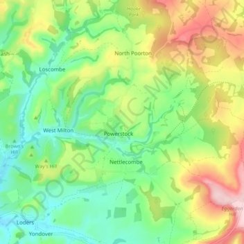
Name: Powerstock topographic map, elevation, terrain.

Location: Powerstock, Dorset, England, United Kingdom (50.74575 -2.72605 50.78713 -2.64159)

Average elevation: 106 m

Minimum elevation: 20 m

Maximum elevation: 247 m

Gear up for your next adventure:

🍳Ultralight Camping Stoves - Boil water quickly for meals using minimal fuel
📖Australian Bush Survival Books - Local knowledge on finding water and surviving the outback
🗺️Topographic Maps - Detailed maps for hiking and navigation
🔭Compact Hiking Binoculars - Lightweight optics for scouting routes or birdwatching
🧼Biodegradable Outdoor Soap - Clean gear and yourself without harming the local ecosystem

As an Amazon Associate, this site earns from qualifying purchases at no extra cost to you.