
Make a donation
Gear up for your next adventure:
As an Amazon Associate, this site earns from qualifying purchases at no extra cost to you.
Jirishanca topographic map
Click on the map to display elevation.
Make a donation
Gear up for your next adventure:
As an Amazon Associate, this site earns from qualifying purchases at no extra cost to you.
Jirishanca
The altitude of 6125 isn't likely as other data from available digital elevation models show lower elevations: SRTM yields 6028 metres and TanDEM-X 5734 metres. The height of the nearest key col is 5610 meters, leading to a topographic prominence of 484 meters. Jirishanca is considered a Mountain according to the Dominance System and its dominance is 7.94%. Its parent peak is Yerupaja and the Topographic isolation is 3.5 kilometers.
Make a donation
Gear up for your next adventure:
As an Amazon Associate, this site earns from qualifying purchases at no extra cost to you.
About this map
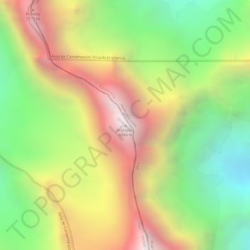
Name: Jirishanca topographic map, elevation, terrain.
Location: Jirishanca, Pacllón, Province of Bolognesi, Ancash, Peru (-10.23703 -76.90579 -10.23693 -76.90569)
Average elevation: 5,198 m
Minimum elevation: 4,510 m
Maximum elevation: 5,907 m
Make a donation
Gear up for your next adventure:
As an Amazon Associate, this site earns from qualifying purchases at no extra cost to you.