
Ljubljana topographic map
Interactive map
Click on the map to display elevation.
About this map
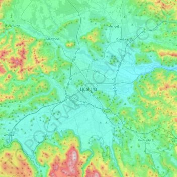
Name: Ljubljana topographic map, elevation, terrain.
Location: Ljubljana, Upravna Enota Ljubljana, 1000, Slovénie (45.88998 14.34686 46.20998 14.66686)
Average elevation: 412 m
Minimum elevation: 251 m
Maximum elevation: 1,094 m
La ville se positionne à 298 m d’altitude dans la vallée de la rivière Ljubljanica entre la région du Karst et la région alpine. Le château, placé au sommet d'une colline au sud du centre-ville, se situe à 366 m d’altitude alors que le point culminant de la ville, nommé Janški Hrib, est perché à 794 m.
Other topographic maps
Click on a map to view its topography, its elevation and its terrain.
Ljubljana central district
Ljubljana central district, Trnovo, Ljubljana, Upravna Enota Ljubljana, Slovénie
Average elevation: 306 m