
Make a donation
Gear up for your next adventure:
As an Amazon Associate, this site earns from qualifying purchases at no extra cost to you.
Manching topographic map
Click on the map to display elevation.
Make a donation
Gear up for your next adventure:
As an Amazon Associate, this site earns from qualifying purchases at no extra cost to you.
About this map
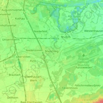
Name: Manching topographic map, elevation, terrain.
Average elevation: 367 m
Minimum elevation: 350 m
Maximum elevation: 397 m
Make a donation
Gear up for your next adventure:
As an Amazon Associate, this site earns from qualifying purchases at no extra cost to you.
Other topographic maps
Click on a map to view its topography, its elevation and its terrain.
Gosseltshausen
Germany > Bavaria > Landkreis Pfaffenhofen an der Ilm > Wolnzach
Average elevation: 427 m
Scheuerhof
Germany > Bavaria > Landkreis Pfaffenhofen an der Ilm > Geisenfeld > Parleiten
Average elevation: 390 m
Oberdünzing
Germany > Bavaria > Landkreis Pfaffenhofen an der Ilm > Vohburg an der Donau
Average elevation: 370 m
Make a donation
Gear up for your next adventure:
As an Amazon Associate, this site earns from qualifying purchases at no extra cost to you.
Jägerbauer
Germany > Bavaria > Landkreis Pfaffenhofen an der Ilm > Wolnzach > Oberlauterbach > Jägerbauer
Average elevation: 456 m