
Make a donation
Gear up for your next adventure:
As an Amazon Associate, this site earns from qualifying purchases at no extra cost to you.
Lake Davis topographic map
Click on the map to display elevation.
Make a donation
Gear up for your next adventure:
As an Amazon Associate, this site earns from qualifying purchases at no extra cost to you.
About this map
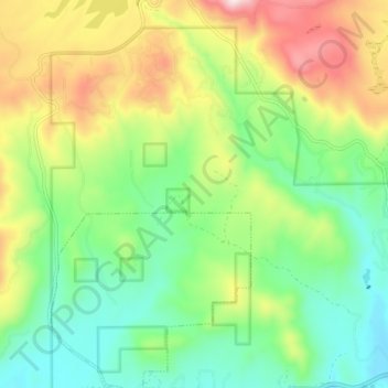
Name: Lake Davis topographic map, elevation, terrain.
Location: Lake Davis, Plumas County, California, United States (39.82203 -120.50023 39.88375 -120.42305)
Average elevation: 1,676 m
Minimum elevation: 1,488 m
Maximum elevation: 1,998 m
Make a donation
Gear up for your next adventure:
As an Amazon Associate, this site earns from qualifying purchases at no extra cost to you.
Other topographic maps
Click on a map to view its topography, its elevation and its terrain.
Lake Almanor Country Club
United States > California > Plumas County > Peninsula Village
Average elevation: 1,388 m
Make a donation
Gear up for your next adventure:
As an Amazon Associate, this site earns from qualifying purchases at no extra cost to you.
Make a donation
Gear up for your next adventure:
As an Amazon Associate, this site earns from qualifying purchases at no extra cost to you.
Lake Almanor Peninsula
United States > California > Plumas County > Peninsula Village
Average elevation: 1,429 m
Make a donation
Gear up for your next adventure:
As an Amazon Associate, this site earns from qualifying purchases at no extra cost to you.