
Bangalore East topographic map
Interactive map
Click on the map to display elevation.
About this map
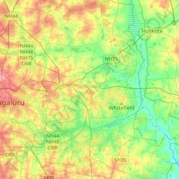
Name: Bangalore East topographic map, elevation, terrain.
Location: Bangalore East, Bengaluru Urban, Karnataka, India (12.87360 77.60309 13.11453 77.78436)
Average elevation: 889 m
Minimum elevation: 847 m
Maximum elevation: 951 m
Other topographic maps
Click on a map to view its topography, its elevation and its terrain.
Kenjar
India > Karnataka > Mangaluru taluk
Kenjar, Mangaluru taluk, Dakshina Kannada district, Karnataka, 575015, India
Average elevation: 27 m
Nidagundi
India > Karnataka > Nidagundi Taluku
Nidagundi, Nidagundi Taluku, Vijayapura district, Karnataka, India
Average elevation: 524 m
Balgallu
India > Karnataka > Kalasa taluk
Balgallu, Kalasa taluk, Chikkamagaluru district, Karnataka, India
Average elevation: 898 m
Kolar
India > Karnataka > Kolar taluk
Kolar, Kolar taluk, Kolar district, Karnataka, 563101, India
Average elevation: 847 m
Belagavi
India > Karnataka > Belagavi taluku > Belagavi
Belagavi, Belagavi taluku, Belgaum district, Karnataka, 590001, India
Average elevation: 760 m
Bengaluru
India > Karnataka > Bangalore North > Bengaluru
Bengaluru, Bangalore North, Bangalore Urban, Karnataka, 560001, India
Average elevation: 879 m
Cave Beach
India > Karnataka > Kumata taluk > Keribele
Cave Beach, Keribele, Kumata taluk, Uttara Kannada, Karnataka, India
Average elevation: 20 m
Kushalanagara
India > Karnataka > Somawarpet taluk > Kushalanagara
Kushalanagara, Somawarpet taluk, Kodagu, Karnataka, 571234, India
Average elevation: 854 m
Udupi
India > Karnataka > Udupi taluku
Udupi, Udupi taluku, Udupi District, Karnataka, 576101, India
Average elevation: 17 m
Channagiri
India > Karnataka > Channagiri
Channagiri, Channagiri taluku, Davanagere district, Karnataka, 577213, India
Average elevation: 679 m
Nagarhole National Park
Nagarhole National Park, Virajpet taluk, Kodagu, Karnataka, India
Average elevation: 808 m
Chikmagalur
Chikmagalur, Chikkamagaluru district, Karnataka, India
Average elevation: 652 m
Garugadahalli
India > Karnataka > Garugadahalli
Garugadahalli, Kaduru taluk, Chikkamagaluru district, Karnataka, India
Average elevation: 726 m
Biligiri Rangana Betta
Biligiri Rangana Betta, Yalanduru taluk, Chamarajanagar district, Karnataka, India
Average elevation: 1,160 m
Shivamogga
India > Karnataka > Shivamogga
Shivamogga, Shivamogga taluku, Shimoga district, Karnataka, 577200, India
Average elevation: 636 m
Hadonahalli
India > Karnataka > Hadonahalli
Hadonahalli, Doddaballapura taluk, Bangalore Rural, Karnataka, India
Average elevation: 913 m
Kyanahalli
India > Karnataka > Kyanahalli
Kyanahalli, Sakaleshapura taluk, Hassan district, Karnataka, India
Average elevation: 909 m
Chikkamagaluru
India > Karnataka > Chikkamagaluru
Chikkamagaluru, Chikkamagaluru taluku, Chikkamagaluru district, Karnataka, 577101, India
Average elevation: 1,052 m
Tadiandamol
Tadiandamol, Madikeri taluku, Kodagu, Karnataka, India
Average elevation: 1,322 m
Baba Budangiri
India > Karnataka > Chikkamagaluru
Baba Budangiri, Chikkamagaluru, Chikkamagaluru taluku, Chikkamagaluru district, Karnataka, 577101, India
Average elevation: 1,628 m
Mangaluru
India > Karnataka > Mangaluru taluk
Mangaluru, Mangaluru taluk, Dakshina Kannada district, Karnataka, 575001, India
Average elevation: 25 m
Dakshina Kannada
Dakshina Kannada, Dakshina Kannada District, Karnataka, 574219, India
Average elevation: 227 m
Manipal
India > Karnataka > Udupi taluku
Manipal, Udupi taluku, Udupi District, Karnataka, 576104, India
Average elevation: 32 m
Sipura
India > Karnataka > Kolar taluk
Sipura, Kolar taluk, Kolar District, Karnataka, 563101, India
Average elevation: 858 m