
Hochsölden topographic map
Interactive map
Click on the map to display elevation.
About this map
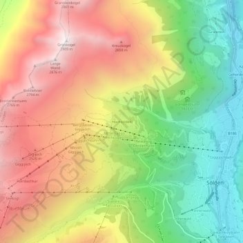
Name: Hochsölden topographic map, elevation, terrain.
Location: Hochsölden, Sölden, Bezirk Imst, 6450, Österreich (46.95742 10.96447 46.99742 11.00447)
Average elevation: 2,068 m
Minimum elevation: 1,301 m
Maximum elevation: 2,885 m
Hochsölden ist ein Hoteldorf im südlichen Teil des Ötztals im Bezirk Imst, Tirol, Österreich. Hochsölden liegt oberhalb von Sölden auf einer Seehöhe von 2083 m ü. A. direkt an der Skipiste.
Other topographic maps
Click on a map to view its topography, its elevation and its terrain.
Steinmandl
Österreich > Bezirk Imst > Sölden
Steinmandl, Sölden, Bezirk Imst, 6458, Österreich
Average elevation: 2,768 m
Zuckerhütl
Österreich > Bezirk Imst > Sölden
Zuckerhütl, Sölden, Bezirk Imst, Österreich
Average elevation: 3,106 m
Hochgurgl
Österreich > Bezirk Imst > Sölden
Hochgurgl, Sölden, Bezirk Imst, 6456, Österreich
Average elevation: 2,277 m