
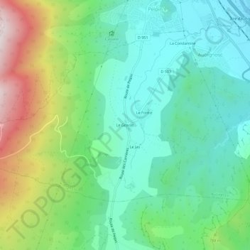
Le Gravas topographic map
Interactive map
Click on the map to display elevation.
About this map
Name: Le Gravas topographic map, elevation, terrain.
Average elevation: 651 m
Minimum elevation: 434 m
Maximum elevation: 1,153 m
Other topographic maps
Click on a map to view its topography, its elevation and its terrain.
Le Forest
France > Provence-Alpes-Côte d'Azur > Alpes-de-Haute-Provence > Aubignosc
Le Forest, Aubignosc, Forcalquier, Alpes-de-Haute-Provence, Provence-Alpes-Côte d'Azur, France métropolitaine, 04200, France
Average elevation: 611 m
La Condamine
France > Provence-Alpes-Côte d'Azur > Alpes-de-Haute-Provence > Aubignosc
La Condamine, Aubignosc, Forcalquier, Alpes-de-Haute-Provence, Provence-Alpes-Côte d'Azur, France métropolitaine, 04200, France
Average elevation: 540 m