
Make a donation
Gear up for your next adventure:
As an Amazon Associate, this site earns from qualifying purchases at no extra cost to you.
Dharamshala topographic map
Click on the map to display elevation.
Make a donation
Gear up for your next adventure:
As an Amazon Associate, this site earns from qualifying purchases at no extra cost to you.
Dharamshala
The town is located in the Kangra Valley, in the shadow of the Dhauladhar range of the Himalayas at an altitude of 1,457 metres (4,780 ft). References to Dharamshala and its surrounding areas are found in ancient Hindu scriptures such as Rig Veda and Mahabharata. The region was under Mughal influence before it was captured by the Sikh empire in 1785. The East India Company captured the region for the British following the First Anglo-Sikh War of 1846, from when it became part of the British Indian province of the Punjab. Post Indian Independence in 1947, it remained as a small hill station. In 1960, the Central Tibetan Administration was moved to Dharamshala when the 14th Dalai Lama Tenzin Gyatso established the Tibetan administration-in-exile after he had to flee Tibet.
Make a donation
Gear up for your next adventure:
As an Amazon Associate, this site earns from qualifying purchases at no extra cost to you.
About this map
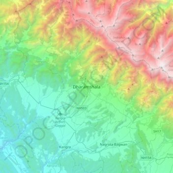
Name: Dharamshala topographic map, elevation, terrain.
Location: Dharamshala, Kangra, Himachal Pradesh, 176200, India (32.05430 76.15967 32.37430 76.47967)
Average elevation: 1,781 m
Minimum elevation: 485 m
Maximum elevation: 4,909 m
Make a donation
Gear up for your next adventure:
As an Amazon Associate, this site earns from qualifying purchases at no extra cost to you.