
Make a donation
Gear up for your next adventure:
As an Amazon Associate, this site earns from qualifying purchases at no extra cost to you.
Passau topographic map
Click on the map to display elevation.
Make a donation
Gear up for your next adventure:
As an Amazon Associate, this site earns from qualifying purchases at no extra cost to you.
Passau
Das Klimadiagramm gibt die Daten einer Messstelle in Fürstenzell (südwestlich an Passau angrenzend) wieder. Allerdings liegt diese Messstelle nahezu 100 Meter höher als Passau selbst.
Make a donation
Gear up for your next adventure:
As an Amazon Associate, this site earns from qualifying purchases at no extra cost to you.
About this map
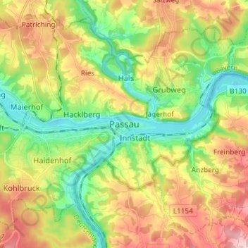
Name: Passau topographic map, elevation, terrain.
Location: Passau, Niederbayern, Bayern, 94032, Deutschland (48.53482 13.42097 48.61482 13.50097)
Average elevation: 380 m
Minimum elevation: 287 m
Maximum elevation: 507 m
Make a donation
Gear up for your next adventure:
As an Amazon Associate, this site earns from qualifying purchases at no extra cost to you.