
Rabac topographic map
Interactive map
Click on the map to display elevation.
About this map
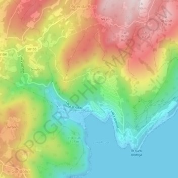
Name: Rabac topographic map, elevation, terrain.
Location: Rabac, Labin, Gespanschaft Istrien, 52221, Kroatien (45.06793 14.14113 45.10100 14.18823)
Average elevation: 173 m
Minimum elevation: -2 m
Maximum elevation: 392 m
Other topographic maps
Click on a map to view its topography, its elevation and its terrain.
Labin
Kroatien > Gespanschaft Istrien > Labin
Labin, Grad Labin, Gespanschaft Istrien, 52220, Kroatien
Average elevation: 216 m