
Make a donation
Gear up for your next adventure:
As an Amazon Associate, this site earns from qualifying purchases at no extra cost to you.
Fürstenfeld topographic map
Click on the map to display elevation.
Make a donation
Gear up for your next adventure:
As an Amazon Associate, this site earns from qualifying purchases at no extra cost to you.
Fürstenfeld
Fürstenfeld is located in the lower Feistritz [ceb; de; sh; sv] valley near the Burgenland border. Elevation of the urban area ranges from 255m to approximately 300 m ü. A. The city`s central part sits on a river terrace two dozen meters above the valley floor.
Make a donation
Gear up for your next adventure:
As an Amazon Associate, this site earns from qualifying purchases at no extra cost to you.
About this map
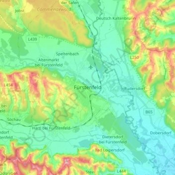
Name: Fürstenfeld topographic map, elevation, terrain.
Average elevation: 283 m
Minimum elevation: 232 m
Maximum elevation: 406 m
Make a donation
Gear up for your next adventure:
As an Amazon Associate, this site earns from qualifying purchases at no extra cost to you.
Other topographic maps
Click on a map to view its topography, its elevation and its terrain.
Stubenberg am See
Austria > Styria > Bezirk Hartberg-Fürstenfeld > Stubenberg
Average elevation: 539 m