
Thank you for supporting this site ❤️
Make a donation
Make a donation
Gear up for your next adventure:
As an Amazon Associate, this site earns from qualifying purchases at no extra cost to you.
Corrientes topographic map
Click on the map to display elevation.
Thank you for supporting this site ❤️
Make a donation
Make a donation
Gear up for your next adventure:
As an Amazon Associate, this site earns from qualifying purchases at no extra cost to you.
About this map
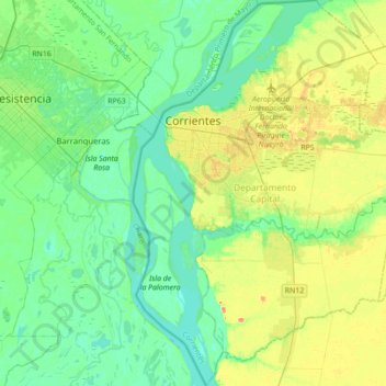
Name: Corrientes topographic map, elevation, terrain.
Location: Corrientes, Departamento Capital, Corrientes, Argentina (-27.68196 -58.88530 -27.37192 -58.62599)
Average elevation: 56 m
Minimum elevation: 41 m
Maximum elevation: 78 m
Thank you for supporting this site ❤️
Make a donation
Make a donation
Gear up for your next adventure:
As an Amazon Associate, this site earns from qualifying purchases at no extra cost to you.