Geolocate

Monster topographic map

Click on the map to display elevation.

About this map

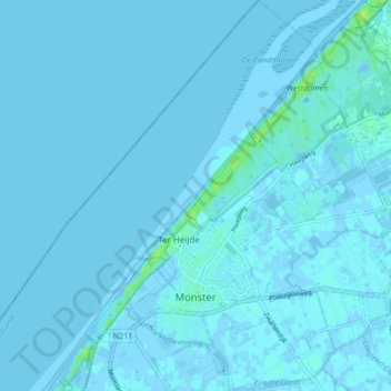
Name: Monster topographic map, elevation, terrain.

Location: Monster, Westland, South Holland, Netherlands (52.00994 4.13961 52.06145 4.21243)

Average elevation: 1 m

Minimum elevation: -3 m

Maximum elevation: 12 m

Other topographic maps

Click on a map to view its topography, its elevation and its terrain.

Langeraar

Netherlands > South Holland

Average elevation: -3 m

Ankerpark

Netherlands > South Holland > Leiden

Average elevation: 3 m

Weerestein

Netherlands > South Holland > Hillegom

Average elevation: 0 m

Weerestein

Netherlands > South Holland > Hillegom

Average elevation: 0 m

Broekhuizen

Netherlands > South Holland > Gouda

Average elevation: -1 m

Middelsluis

Netherlands > South Holland > Numansdorp

Average elevation: 0 m

Meije

Netherlands > South Holland > Nieuwkoop

Average elevation: -2 m

Botlek

Netherlands > South Holland

Average elevation: 3 m

Meijendel

Netherlands > South Holland > Wassenaar

Average elevation: 6 m

Coepelduynen

Netherlands > South Holland > Katwijk

Average elevation: 4 m

Het Park

Netherlands > South Holland > Rotterdam

Average elevation: 4 m

Waalhaven

Netherlands > South Holland > Rotterdam

Average elevation: 3 m

Gear up for your next adventure:

🎒Ultralight Backpacks - Lightweight packs for long hikes
🕶️Polarized Outdoor Sunglasses - Reduce glare from rocks and water for better visual navigation
📕Australia Maps - Maps covering Australian regions
🥤Hydration Packs - Hydration systems for hiking
💡Collapsible Camping Lanterns - Illuminate your base camp or tent for map studying at night

As an Amazon Associate, this site earns from qualifying purchases at no extra cost to you.