
Sölden topographic map
Interactive map
Click on the map to display elevation.
About this map
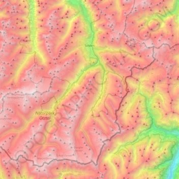
Name: Sölden topographic map, elevation, terrain.
Location: Sölden, Bezirk Imst, Autriche (46.76285 10.72601 47.02239 11.16810)
Average elevation: 2,483 m
Minimum elevation: 499 m
Maximum elevation: 3,721 m
Le village principal de Sölden est à une altitude de 1 368 mètres et le village de Hochsölden se trouvant à une altitude de 2 090 m possède 5 hôtels quatre étoiles. Le point culminant est le Wildspitze, à 3 768 m. Il s'agit de la deuxième plus haute montagne d'Autriche après le Grossglockner.
Other topographic maps
Click on a map to view its topography, its elevation and its terrain.
Klingenburg
Autriche > Bezirk Imst > Oetz
Klingenburg, Oetz, Bezirk Imst, 6433, Autriche
Average elevation: 1,162 m
Holzleiten
Autriche > Bezirk Imst > Obsteig
Holzleiten, Obsteig, Bezirk Imst, 6416, Autriche
Average elevation: 1,262 m
Vent
Autriche > Bezirk Imst > Sölden
Vent, Sölden, Bezirk Imst, Tyrol, 6458, Autriche
Average elevation: 2,371 m