
Landerneau topographic map
Interactive map
Click on the map to display elevation.
About this map
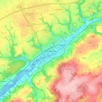
Name: Landerneau topographic map, elevation, terrain.
Average elevation: 87 m
Minimum elevation: -3 m
Maximum elevation: 182 m
Other topographic maps
Click on a map to view its topography, its elevation and its terrain.
Les Quatres Vents
Frankreich > Bretagne > Finistère > La Forest-Landerneau > Les Quatres Vents
Les Quatres Vents, La Forest-Landerneau, Brest, Finistère, Bretagne, Metropolitanes Frankreich, 29800, Frankreich
Average elevation: 79 m
Saint-Pol-de-Léon
Frankreich > Bretagne > Finistère
Saint-Pol-de-Léon, Morlaix, Finistère, Bretagne, Metropolitanes Frankreich, 29250, Frankreich
Average elevation: 26 m