
Make a donation
Gear up for your next adventure:
As an Amazon Associate, this site earns from qualifying purchases at no extra cost to you.
Wiesent topographic map
Click on the map to display elevation.
Make a donation
Gear up for your next adventure:
As an Amazon Associate, this site earns from qualifying purchases at no extra cost to you.
Wiesent
Im Zuge der Gebietsreform in Bayern wurden am 1. Januar 1972 die Gemeinden Dietersweg und Kruckenberg jeweils mit allen ihren Gemeindeteilen eingegliedert. Dietersweg brachte die Gemeindeteile Dietersweg, Eckenzell, Eidenzell, Grafenöd, Heilsberg, Hermannsöd, Höhenberg, Kirnberg, Mitterroith, Neuhaus, Pangerlhof, Pinklhof (Oberroith), Ponhof, Rupertsbühl, Sandweg und Wiedenrös ein, Kruckenberg und Lehmhof stammen aus der ehemaligen Gemeinde Kruckenberg. Mit der Gebietsreform erfolgte die Eingliederung in die Verwaltungsgemeinschaft Wörth. Am 1. Januar 1980 erlangte Wiesent aber erneut die Selbstständigkeit. Zum 1. Juli 2014 wurden 4,6262 km² aus dem gemeindefreien Gebiet Forstmühler Forst in die Gemeinde Wiesent umgegliedert.
Make a donation
Gear up for your next adventure:
As an Amazon Associate, this site earns from qualifying purchases at no extra cost to you.
About this map
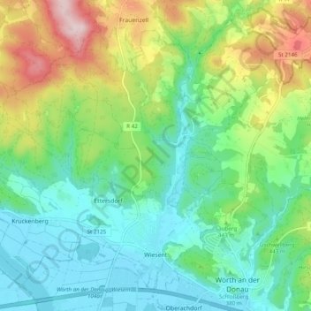
Name: Wiesent topographic map, elevation, terrain.
Location: Wiesent, Landkreis Regensburg, Bayern, 93109, Deutschland (48.99981 12.31943 49.05519 12.41618)
Average elevation: 427 m
Minimum elevation: 322 m
Maximum elevation: 666 m
Make a donation
Gear up for your next adventure:
As an Amazon Associate, this site earns from qualifying purchases at no extra cost to you.
Other topographic maps
Click on a map to view its topography, its elevation and its terrain.
Make a donation
Gear up for your next adventure:
As an Amazon Associate, this site earns from qualifying purchases at no extra cost to you.
Make a donation
Gear up for your next adventure:
As an Amazon Associate, this site earns from qualifying purchases at no extra cost to you.
Make a donation
Gear up for your next adventure:
As an Amazon Associate, this site earns from qualifying purchases at no extra cost to you.
Hainsacker
Deutschland > Bayern > Landkreis Regensburg
Altenried | Aschach | Baiern | Benhof | Einhausen | Geiersberg | Gewald | Hainsacker | Harreshof | Hohensand | Hönighausen | Kareth | Kaulhausen | Knieschlag | Landlhof | Lappersdorf | Lorenzen | Oppersdorf | Pielmühle | Rehthal | Rodau | Schinderwies | Schwaighausen | Schwärz | Schwerdnermühle | Steinhof…
Average elevation: 402 m
Make a donation
Gear up for your next adventure:
As an Amazon Associate, this site earns from qualifying purchases at no extra cost to you.
Wörth an der Donau
Deutschland > Bayern > Landkreis Regensburg > Wörth an der Donau > Wörth an der Donau
Average elevation: 379 m
Make a donation
Gear up for your next adventure:
As an Amazon Associate, this site earns from qualifying purchases at no extra cost to you.
Wichenbach
Deutschland > Bayern > Landkreis Regensburg > Wörth an der Donau > Tiefenthal
Average elevation: 376 m
Make a donation
Gear up for your next adventure:
As an Amazon Associate, this site earns from qualifying purchases at no extra cost to you.
Make a donation
Gear up for your next adventure:
As an Amazon Associate, this site earns from qualifying purchases at no extra cost to you.
Make a donation
Gear up for your next adventure:
As an Amazon Associate, this site earns from qualifying purchases at no extra cost to you.
Make a donation
Gear up for your next adventure:
As an Amazon Associate, this site earns from qualifying purchases at no extra cost to you.
Make a donation
Gear up for your next adventure:
As an Amazon Associate, this site earns from qualifying purchases at no extra cost to you.
Make a donation
Gear up for your next adventure:
As an Amazon Associate, this site earns from qualifying purchases at no extra cost to you.
Make a donation
Gear up for your next adventure:
As an Amazon Associate, this site earns from qualifying purchases at no extra cost to you.
Make a donation
Gear up for your next adventure:
As an Amazon Associate, this site earns from qualifying purchases at no extra cost to you.
Danersdorf
Deutschland > Bayern > Landkreis Regensburg > Regenstauf > Gnadenhof
Average elevation: 482 m
Make a donation
Gear up for your next adventure:
As an Amazon Associate, this site earns from qualifying purchases at no extra cost to you.
Wenzenbach
Deutschland > Bayern > Landkreis Regensburg > Probstberg > Zeitlhof
Average elevation: 389 m
Holzheim am Forst
Deutschland > Bayern > Landkreis Regensburg > Holzheim am Forst > Holzheim am Forst
Average elevation: 391 m
Make a donation
Gear up for your next adventure:
As an Amazon Associate, this site earns from qualifying purchases at no extra cost to you.
Kollersried
Deutschland > Bayern > Landkreis Regensburg > Hemau > Laufenthal > Kollersried
Average elevation: 501 m
Neuhaus
Deutschland > Bayern > Landkreis Regensburg > Regenstauf > Diesenbach
Average elevation: 365 m
Make a donation
Gear up for your next adventure:
As an Amazon Associate, this site earns from qualifying purchases at no extra cost to you.
Make a donation
Gear up for your next adventure:
As an Amazon Associate, this site earns from qualifying purchases at no extra cost to you.