
Scarista topographic map
Interactive map
Click on the map to display elevation.
About this map
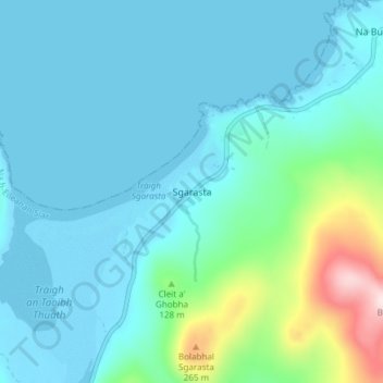
Name: Scarista topographic map, elevation, terrain.
Location: Scarista, Western Isles, Scotland, HS3 3HX, United Kingdom (57.80553 -7.06315 57.84553 -7.02315)
Average elevation: 60 m
Minimum elevation: -1 m
Maximum elevation: 388 m
Other topographic maps
Click on a map to view its topography, its elevation and its terrain.
Reef
United Kingdom > Scotland > Western Isles
Reef, Western Isles, Scotland, HS2 9HU, United Kingdom
Average elevation: 18 m
Àird
United Kingdom > Scotland > Western Isles
Àird, Western Isles, Scotland, United Kingdom, Benbecula
Average elevation: 5 m
Vatersay
United Kingdom > Scotland > Western Isles > Vatersay
Vatersay, Western Isles, Scotland, United Kingdom
Average elevation: 19 m
Tong
United Kingdom > Scotland > Western Isles
Tong, Western Isles, Scotland, HS2 0HJ, United Kingdom
Average elevation: 15 m
Tarbert
United Kingdom > Scotland > Western Isles
Tarbert, Western Isles, Scotland, HS3 3DB, United Kingdom
Average elevation: 87 m
St Kilda
United Kingdom > Scotland > Western Isles
St Kilda, Western Isles, Scotland, United Kingdom
Average elevation: 11 m