Geolocate

Angono topographic map

Click on the map to display elevation.

About this map

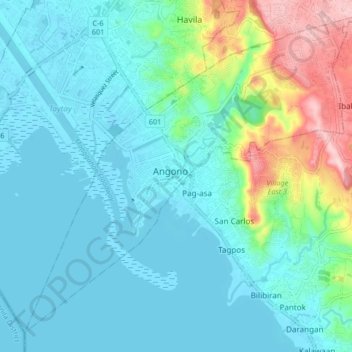
Name: Angono topographic map, elevation, terrain.

Location: Angono, Rizal, Calabarzon, 1930, Philippines (14.48513 121.11398 14.56513 121.19398)

Average elevation: 47 m

Minimum elevation: -3 m

Maximum elevation: 238 m

Other topographic maps

Click on a map to view its topography, its elevation and its terrain.

Mahabang Parang

Philippines > Rizal > Angono

Average elevation: 174 m

Carebi Village

Philippines > Rizal > Angono > Tayuman

Average elevation: 11 m

San Isidro

Philippines > Rizal > Angono

Average elevation: 36 m

San Roque

Philippines > Rizal > Angono

Average elevation: 37 m

Mahabang Parang

Philippines > Rizal > Angono

Average elevation: 174 m

Gear up for your next adventure:

🔑Heavy Duty Carabiners - Secure gear to the outside of your pack for easy access
GPS Watches - GPS watches for outdoor sports
🎨Portable Watercolor Kits - Paint the landscapes and topographic views you discover
👟Lightweight Trail Runners - Agile footwear for fast movement over rugged Australian terrain
🦟Insect Repellent - Protection against insects

As an Amazon Associate, this site earns from qualifying purchases at no extra cost to you.