
Gisors topographic map
Interactive map
Click on the map to display elevation.
About this map
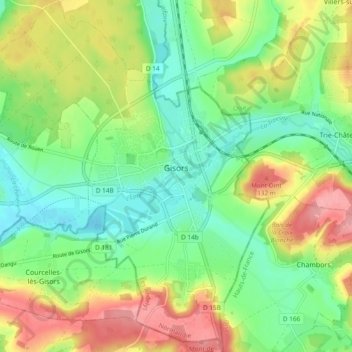
Name: Gisors topographic map, elevation, terrain.
Average elevation: 84 m
Minimum elevation: 42 m
Maximum elevation: 147 m
Die am Zusammenfluss der Epte, der Troësne und des Réveillon gelegene Stadt Gisors ist die östlichste Gemeinde der Normandie. Sie liegt in der Kulturlandschaft des Vexin auf der Grenze zwischen dem Vexin normand und dem Vexin français in einer Höhe von ca. 75 m. Das vom ca. 100 lm (Luftlinie) entfernten Atlantik beeinflusste Klima ist gemäßigt; Regen (ca. 700–800 mm/Jahr) fällt überwiegend in den Wintermonaten.
Other topographic maps
Click on a map to view its topography, its elevation and its terrain.
Les Damps
Frankreich > Normandie > Eure > Les Damps
Les Damps, Les Andelys, Eure, Normandie, Metropolitanes Frankreich, 27340, Frankreich
Average elevation: 63 m