
Karlspitze topographic map
Interactive map
Click on the map to display elevation.
About this map
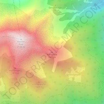
Name: Karlspitze topographic map, elevation, terrain.
Average elevation: 1,377 m
Minimum elevation: 586 m
Maximum elevation: 2,116 m
Other topographic maps
Click on a map to view its topography, its elevation and its terrain.
Hutterer Böden
Österreich > Oberösterreich > Bezirk Kirchdorf > Hinterstoder
Hutterer Böden, Hinterstoder, Bezirk Kirchdorf, Oberösterreich, 4573, Österreich
Average elevation: 1,327 m