
Nyewente topographic map
Interactive map
Click on the map to display elevation.
About this map
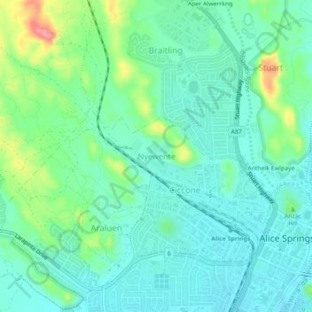
Name: Nyewente topographic map, elevation, terrain.
Average elevation: 597 m
Minimum elevation: 573 m
Maximum elevation: 668 m
Other topographic maps
Click on a map to view its topography, its elevation and its terrain.
Ilparpa
Australia > Town of Alice Springs
Ilparpa, Town of Alice Springs, Northern Territory, Australia
Average elevation: 581 m
Alice Springs
Australia > Town of Alice Springs
Alice Springs, Town of Alice Springs, Northern Territory, 4992, Australia
Average elevation: 584 m
Mpwetyerre
Australia > Town of Alice Springs
Mpwetyerre, Town of Alice Springs, Northern Territory, 0870, Australia
Average elevation: 592 m
Aper Alwerrkng
Australia > Town of Alice Springs > Aper Alwerrkng
Aper Alwerrkng, Stuart, Town of Alice Springs, Northern Territory, 0871, Australia
Average elevation: 609 m
Connellan
Australia > Town of Alice Springs > Connellan
Connellan, Town of Alice Springs, Northern Territory, 0873, Australia
Average elevation: 548 m
Anzac Hill
Australia > Town of Alice Springs > Alice Springs
Anzac Hill, Alice Springs, Town of Alice Springs, Northern Territory, 0870, Australia
Average elevation: 586 m
White Gums
Australia > Town of Alice Springs
White Gums, Town of Alice Springs, Northern Territory, Australia
Average elevation: 594 m