
D'Hutte topographic map
Interactive map
Click on the map to display elevation.
About this map
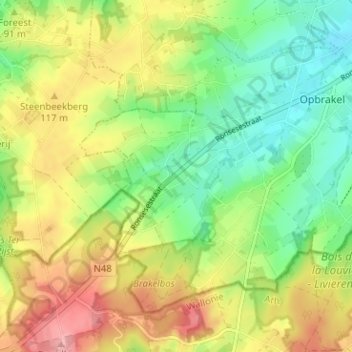
Name: D'Hutte topographic map, elevation, terrain.
Average elevation: 91 m
Minimum elevation: 37 m
Maximum elevation: 161 m
Other topographic maps
Click on a map to view its topography, its elevation and its terrain.
Brakelbos
België > Oost-Vlaanderen > Oudenaarde > Opbrakel > D'Hutte
Brakelbos, Hof Ten Bosscheweg, D'Hutte, Opbrakel, Brakel, Oudenaarde, Oost-Vlaanderen, Vlaanderen, 9660, België
Average elevation: 102 m