
Emsbüren topographic map
Interactive map
Click on the map to display elevation.
About this map
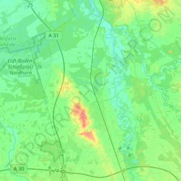
Name: Emsbüren topographic map, elevation, terrain.
Location: Emsbüren, Landkreis Emsland, Lower Saxony, 48488, Germany (52.33388 7.21252 52.48261 7.42664)
Average elevation: 32 m
Minimum elevation: 19 m
Maximum elevation: 71 m
Other topographic maps
Click on a map to view its topography, its elevation and its terrain.
Lingen (Ems)
Germany > Lower Saxony > Landkreis Emsland
Lingen (Ems), Landkreis Emsland, Lower Saxony, Germany
Average elevation: 29 m
Wörmer
Germany > Lower Saxony > Landkreis Emsland > Haren (Ems) > Wesuwe
Wörmer, Wesuwe, Haren (Ems), Landkreis Emsland, Lower Saxony, 49733, Germany
Average elevation: 12 m
Dever
Germany > Lower Saxony > Landkreis Emsland > Lehe
Dever, Lehe, Samtgemeinde Dörpen, Landkreis Emsland, Lower Saxony, 26892, Germany
Average elevation: 6 m