Geolocate

Kemsing topographic map

Click on the map to display elevation.

About this map

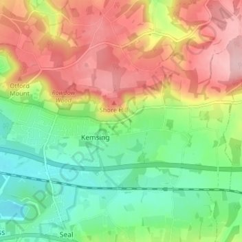
Name: Kemsing topographic map, elevation, terrain.

Location: Kemsing, Sevenoaks, Kent, England, United Kingdom (51.29554 0.20294 51.32191 0.26813)

Average elevation: 139 m

Minimum elevation: 62 m

Maximum elevation: 234 m

👉 Easily get elevation data in JSON, GeoTIFF and KML formats using Elevation API
Thank you for supporting this site ❤️
Make a donation

Gear up for your next adventure:

As an Amazon Associate, this site earns from qualifying purchases at no extra cost to you.

Other topographic maps

Click on a map to view its topography, its elevation and its terrain.

Seal Chart

United Kingdom > England > Kent > Sevenoaks > Styants Bottom

Average elevation: 143 m

Knockholt Pound

United Kingdom > England > Kent > Sevenoaks

Average elevation: 169 m

Godden Green

United Kingdom > England > Kent > Sevenoaks

Average elevation: 144 m

Halstead

United Kingdom > England > Kent > Sevenoaks

Average elevation: 156 m

Ash

United Kingdom > England > Kent > Sevenoaks

Average elevation: 139 m

South Darenth

United Kingdom > England > Kent > Sevenoaks

Average elevation: 50 m

Heaverham

United Kingdom > England > Kent > Sevenoaks

Average elevation: 142 m

Knatts Valley

United Kingdom > England > Kent > Sevenoaks > East Hill > Knockmill

Average elevation: 170 m

Lett's Green

United Kingdom > England > Kent > Sevenoaks > Knockholt

Average elevation: 183 m

Hosey Hill

United Kingdom > England > Kent > Sevenoaks

Average elevation: 151 m

Badger's Mount

United Kingdom > England > Kent > Sevenoaks

Average elevation: 138 m

Sundridge

United Kingdom > England > Kent > Sevenoaks

Average elevation: 116 m

Horseshoe Green

United Kingdom > England > Kent > Sevenoaks > Markbeech

Average elevation: 86 m

Toy's Hill

United Kingdom > England > Kent > Sevenoaks

Average elevation: 159 m

Betsom's Hill

United Kingdom > England > Kent > Sevenoaks

Average elevation: 190 m

Chiddingstone Hoath

United Kingdom > England > Kent > Sevenoaks

Average elevation: 75 m

Ide Hill

United Kingdom > England > Kent > Sevenoaks

Average elevation: 151 m

Chevening

United Kingdom > England > Kent > Sevenoaks

Average elevation: 126 m

Bore Place

United Kingdom > England > Kent > Sevenoaks > Chiddingstone

Average elevation: 76 m

Crockham Hill

United Kingdom > England > Kent > Sevenoaks

Average elevation: 118 m

Horton Kirby

United Kingdom > England > Kent > Sevenoaks

Average elevation: 63 m

Hill Hoath

United Kingdom > England > Kent > Sevenoaks > Hill Hoath

Average elevation: 59 m

Four Elms

United Kingdom > England > Kent > Sevenoaks

Average elevation: 67 m

Fawkham Green

United Kingdom > England > Kent > Sevenoaks

Average elevation: 125 m

Weardale

United Kingdom > England > Kent > Sevenoaks > French Street

Average elevation: 171 m

Sundridge

United Kingdom > England > Kent > Sevenoaks

Average elevation: 116 m

Ridley

United Kingdom > England > Kent > Sevenoaks > Hodsoll Street

Average elevation: 146 m

New Ash Green

United Kingdom > England > Kent > Sevenoaks

Average elevation: 123 m

Gear up for your next adventure:

🍳Ultralight Camping Stoves - Boil water quickly for meals using minimal fuel
🩹Wilderness First Aid Kits - Comprehensive medical kits tailored for hiking and remote exploration
🪢550 Survival Paracord - Versatile cordage for gear repair and emergency lashing
🔪Outdoor Multi-tools - Versatile tools for gear repair and survival tasks in the wilderness
🥾Hiking Gaiters - Leg protection for trails

As an Amazon Associate, this site earns from qualifying purchases at no extra cost to you.