
Make a donation
Gear up for your next adventure:
As an Amazon Associate, this site earns from qualifying purchases at no extra cost to you.
Selenge topographic map
Click on the map to display elevation.
Make a donation
Gear up for your next adventure:
As an Amazon Associate, this site earns from qualifying purchases at no extra cost to you.
About this map
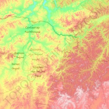
Name: Selenge topographic map, elevation, terrain.
Location: Selenge, Mongolia (48.50478 104.36327 50.47950 108.57140)
Average elevation: 1,146 m
Minimum elevation: 551 m
Maximum elevation: 2,707 m
Make a donation
Gear up for your next adventure:
As an Amazon Associate, this site earns from qualifying purchases at no extra cost to you.
Other topographic maps
Click on a map to view its topography, its elevation and its terrain.
Burkhan Khaldun
Mongolia > Khentii > Omnodelger
Burkhan Khaldun means the "God Mountain" and is also called Khentii Khan (The King of the Khentii Mountain range). It is one of the Khentii Mountains in the Khentii Province of northeastern Mongolia. It is the highest mountain of the region, rising to an elevation of 2,362 metres (7,749 ft), and is…
Average elevation: 2,113 m
Make a donation
Gear up for your next adventure:
As an Amazon Associate, this site earns from qualifying purchases at no extra cost to you.