
Fencott topographic map
Click on the map to display elevation.
About this map
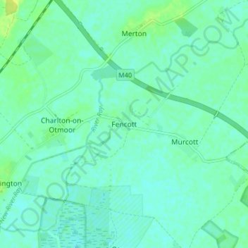
Name: Fencott topographic map, elevation, terrain.
Average elevation: 61 m
Minimum elevation: 56 m
Maximum elevation: 71 m
Other topographic maps
Click on a map to view its topography, its elevation and its terrain.
Roman Meadow Banbury Country Park
United Kingdom > England > Oxfordshire > Cherwell District > Little Bourton
Average elevation: 103 m
Weston-on-the-Green
United Kingdom > England > Oxfordshire > Cherwell District
Average elevation: 72 m
Bicester
United Kingdom > England > Oxfordshire > Cherwell District
Bicester has expanded rapidly in recent generations due to the town's picturesque historical town centre, garden town layout, independent and high-street shops, restaurants, as well as a rail connection to Oxford. It also boasts imminent connection to Cambridge, as well as rail links to Birmingham and London.…
Average elevation: 77 m
Deddington
United Kingdom > England > Oxfordshire > Cherwell District
Clifton, Deddington and Hempton stand on a ridge of Jurassic ferruginous marlstone hills between the three watercourses. Clifton is about 1+1⁄2 miles (2.4 km) east of Deddington, at the eastern end of the ridge where it slopes down to the Cherwell. The ridges rises westward. Deddington is about 430 feet (130…
Average elevation: 107 m
Horton-cum-Studley
United Kingdom > England > Oxfordshire > Cherwell District > Horton-cum-Studley
Average elevation: 71 m
The Lake
United Kingdom > England > Oxfordshire > Cherwell District > Hardwick
Average elevation: 120 m
Stoke Lyne
United Kingdom > England > Oxfordshire > Cherwell District > Stoke Lyne
Average elevation: 116 m
Begbroke
United Kingdom > England > Oxfordshire > Cherwell District > Begbroke
Average elevation: 75 m
Cropredy
United Kingdom > England > Oxfordshire > Cherwell District > Cropredy
Average elevation: 124 m
South Newington
United Kingdom > England > Oxfordshire > Cherwell District > South Newington
Average elevation: 139 m