
Mount Arapiles topographic map
Interactive map
Click on the map to display elevation.
About this map
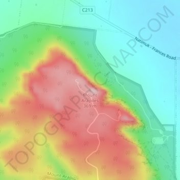
Name: Mount Arapiles topographic map, elevation, terrain.
Location: Mount Arapiles, Rural City of Horsham, Victoria, Australia (-36.75228 141.83529 -36.75218 141.83539)
Average elevation: 219 m
Minimum elevation: 116 m
Maximum elevation: 362 m
Other topographic maps
Click on a map to view its topography, its elevation and its terrain.
Black Range State Park
Australia > Victoria > Horsham
Black Range State Park, Mount Byron Walk, Brimpaen, Horsham, Rural City of Horsham, Grampians, Victoria, Australia
Average elevation: 233 m
St Helens Plains
Australia > Victoria > Horsham
St Helens Plains, Horsham, Rural City of Horsham, Grampians, Victoria, Australia
Average elevation: 151 m