
Make a donation
Gear up for your next adventure:
As an Amazon Associate, this site earns from qualifying purchases at no extra cost to you.
Courtallam topographic map
Click on the map to display elevation.
Make a donation
Gear up for your next adventure:
As an Amazon Associate, this site earns from qualifying purchases at no extra cost to you.
Courtallam
Courtallam, natively spelt Kutrālam or Kuttālam, is a panchayat town situated at a mean elevation of 160 m (520 ft) in the foothills of the Western Ghats in Tenkasi district of Tamil Nadu, India. The Coutrallam Falls on the Chittar River is a major tourist attraction.
Make a donation
Gear up for your next adventure:
As an Amazon Associate, this site earns from qualifying purchases at no extra cost to you.
About this map
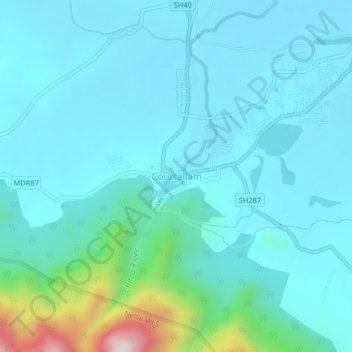
Name: Courtallam topographic map, elevation, terrain.
Location: Courtallam, Tenkasi, Tamil Nadu, 627802, India (8.91288 77.25146 8.95288 77.29146)
Average elevation: 239 m
Minimum elevation: 152 m
Maximum elevation: 768 m
Make a donation
Gear up for your next adventure:
As an Amazon Associate, this site earns from qualifying purchases at no extra cost to you.