
Thank you for supporting this site ❤️
Make a donation
Make a donation
Gear up for your next adventure:
As an Amazon Associate, this site earns from qualifying purchases at no extra cost to you.
Tula topographic map
Click on the map to display elevation.
Thank you for supporting this site ❤️
Make a donation
Make a donation
Gear up for your next adventure:
As an Amazon Associate, this site earns from qualifying purchases at no extra cost to you.
About this map
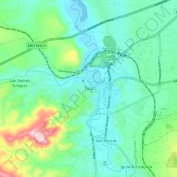
Name: Tula topographic map, elevation, terrain.
Location: Tula, Tula de Allende, Hidalgo, 42800, Mexico (20.01170 -99.38507 20.09170 -99.30507)
Average elevation: 2,100 m
Minimum elevation: 2,020 m
Maximum elevation: 2,362 m
Thank you for supporting this site ❤️
Make a donation
Make a donation
Gear up for your next adventure:
As an Amazon Associate, this site earns from qualifying purchases at no extra cost to you.