
Thank you for supporting this site ❤️
Make a donation
Make a donation
Gear up for your next adventure:
As an Amazon Associate, this site earns from qualifying purchases at no extra cost to you.
Bolenberg topographic map
Click on the map to display elevation.
Thank you for supporting this site ❤️
Make a donation
Make a donation
Gear up for your next adventure:
As an Amazon Associate, this site earns from qualifying purchases at no extra cost to you.
About this map
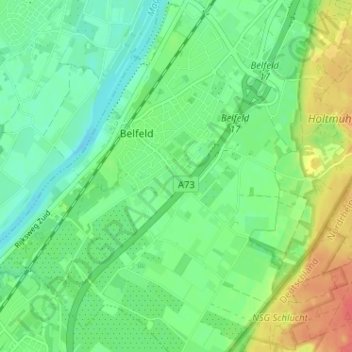
Name: Bolenberg topographic map, elevation, terrain.
Average elevation: 28 m
Minimum elevation: 9 m
Maximum elevation: 63 m
Thank you for supporting this site ❤️
Make a donation
Make a donation
Gear up for your next adventure:
🎒40L Day Hiking Backpacks - Comfortable packs with hydration support for long days exploring topographic peaks
As an Amazon Associate, this site earns from qualifying purchases at no extra cost to you.