
Thank you for supporting this site ❤️
Make a donation
Make a donation
Gear up for your next adventure:
As an Amazon Associate, this site earns from qualifying purchases at no extra cost to you.
Cambridge topographic map
Click on the map to display elevation.
Thank you for supporting this site ❤️
Make a donation
Make a donation
Gear up for your next adventure:
As an Amazon Associate, this site earns from qualifying purchases at no extra cost to you.
About this map
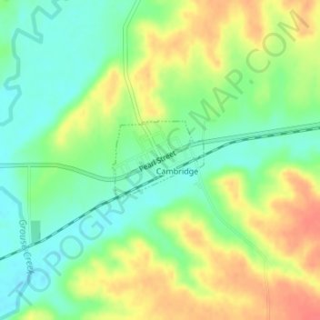
Name: Cambridge topographic map, elevation, terrain.
Location: Cambridge, Cowley County, Kansas, United States (37.31374 -96.67134 37.32038 -96.66164)
Average elevation: 397 m
Minimum elevation: 373 m
Maximum elevation: 427 m
Thank you for supporting this site ❤️
Make a donation
Make a donation
Gear up for your next adventure:
As an Amazon Associate, this site earns from qualifying purchases at no extra cost to you.
Other topographic maps
Click on a map to view its topography, its elevation and its terrain.
Arkansas City
United States > Kansas > Cowley County > Arkansas City > Arkansas City
Average elevation: 339 m