
Make a donation
Gear up for your next adventure:
As an Amazon Associate, this site earns from qualifying purchases at no extra cost to you.
Kerman Province topographic map
Click on the map to display elevation.
Make a donation
Gear up for your next adventure:
As an Amazon Associate, this site earns from qualifying purchases at no extra cost to you.
Kerman Province
The altitudes and heights of the province are the continuation of the central mountain ranges of Iran. They extend from the volcanic folds beginning in Azerbaijan and, by branching out in the central plateau of Iran, terminate in Baluchestan. These mountain ranges have brought about vast plains in the province. The Bashagard and Kuhbonan Mountains are the highest in this region and include peaks such as Toghrol, Aljerd, Palvar, Sirach, Abareq and Tahrood. Other ranges that stretch out from Yazd to Kerman and Challeh-ye-Jazmoorian include high peaks like Hazaran 4501 meters above sea level, Kuh-e Shah 4402 meters, Joupar, Bahr Aseman and Khabr mountain in Khabr National Park and others.
Make a donation
Gear up for your next adventure:
As an Amazon Associate, this site earns from qualifying purchases at no extra cost to you.
About this map
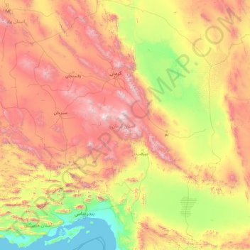
Name: Kerman Province topographic map, elevation, terrain.
Location: Kerman Province, Iran (26.44500 54.37031 31.95696 59.72550)
Average elevation: 1,150 m
Minimum elevation: -1 m
Maximum elevation: 4,224 m
Make a donation
Gear up for your next adventure:
As an Amazon Associate, this site earns from qualifying purchases at no extra cost to you.
Other topographic maps
Click on a map to view its topography, its elevation and its terrain.
Shurab
Iran > South Khorasan Province > Birjand County > دهستان شاخن > Foorjan
Average elevation: 1,935 m
Espakeh
Iran > Sistan and Baluchestan Province > Lashar County > دهستان لاشارشمالی
Average elevation: 776 m
Now
Iran > Chaharmahal and Bakhtiyari Province > Lordegan County > Sardasht Rural District
Average elevation: 1,871 m
Make a donation
Gear up for your next adventure:
As an Amazon Associate, this site earns from qualifying purchases at no extra cost to you.
Gold
Iran > Chaharmahal and Bakhtiyari Province > Lordegan County > Sardasht Rural District
Average elevation: 1,739 m
Make a donation
Gear up for your next adventure:
As an Amazon Associate, this site earns from qualifying purchases at no extra cost to you.
Shalan
Iran > Kermanshah Province > Kermanshah County > (هوره سو)دهستان قره سو
Average elevation: 1,515 m
Make a donation
Gear up for your next adventure:
As an Amazon Associate, this site earns from qualifying purchases at no extra cost to you.
Make a donation
Gear up for your next adventure:
As an Amazon Associate, this site earns from qualifying purchases at no extra cost to you.
Make a donation
Gear up for your next adventure:
As an Amazon Associate, this site earns from qualifying purchases at no extra cost to you.
Kerrawa
Iran > Kurdistan Province > Sarvabad County > دهستان رزآب > Kerrawa
Average elevation: 1,426 m
Sib
Iran > Sistan and Baluchestan Province > Sib and Suran County > دهستان سیب وسوران > Sib
Average elevation: 1,146 m
Make a donation
Gear up for your next adventure:
As an Amazon Associate, this site earns from qualifying purchases at no extra cost to you.