
Auch topographic map
Interactive map
Click on the map to display elevation.
About this map
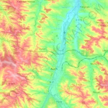
Name: Auch topographic map, elevation, terrain.
Location: Auch, Gers, Occitanie, France métropolitaine, 32000, France (43.61719 0.48604 43.70772 0.64709)
Average elevation: 190 m
Minimum elevation: 114 m
Maximum elevation: 284 m
L'altitude est comprise entre 115 m et 281 m, avec une moyenne de 198 m. La mairie est à 134 m d'altitude.
Other topographic maps
Click on a map to view its topography, its elevation and its terrain.
Villecomtal-sur-Arros
Villecomtal-sur-Arros, Mirande, Gers, Occitanie, France métropolitaine, 32730, France
Average elevation: 206 m
Au Thuillie
France > Occitanie > Gers > Cazaubon
Au Thuillie, Sentou, Cazaubon, Condom, Gers, Occitanie, France métropolitaine, 32150, France
Average elevation: 121 m