
Make a donation
Gear up for your next adventure:
As an Amazon Associate, this site earns from qualifying purchases at no extra cost to you.
Idar-Oberstein topographic map
Click on the map to display elevation.
Make a donation
Gear up for your next adventure:
As an Amazon Associate, this site earns from qualifying purchases at no extra cost to you.
Idar-Oberstein
Idar-Oberstein/Göttschied Airfield lies north of the town between the constituent community of Göttschied and the municipalities of Gerach and Hintertiefenbach at an elevation of 480 m above sea level (1,575 feet). Its ICAO location indicator is EDRG. The grass landing strip's orientation is 06/24, and it is 650 m long and 50 m wide. The allowable landing weight is 2 000 kg; however, with PPR (“prior permission required”), aircraft of up to 3 700 kg may land. The airport is designed for helicopters, motor gliders, gliders, ultralights and, also with PPR, skydivers.
Make a donation
Gear up for your next adventure:
As an Amazon Associate, this site earns from qualifying purchases at no extra cost to you.
About this map
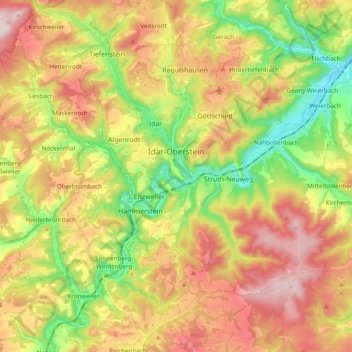
Name: Idar-Oberstein topographic map, elevation, terrain.
Average elevation: 406 m
Minimum elevation: 210 m
Maximum elevation: 617 m
Make a donation
Gear up for your next adventure:
As an Amazon Associate, this site earns from qualifying purchases at no extra cost to you.