
Thank you for supporting this site ❤️
Make a donation
Make a donation
Gear up for your next adventure:
As an Amazon Associate, this site earns from qualifying purchases at no extra cost to you.
Aomar topographic map
Click on the map to display elevation.
Thank you for supporting this site ❤️
Make a donation
Make a donation
Gear up for your next adventure:
🆘Personal Locator Beacons (PLB) - Satellite emergency beacons for life-saving help in areas with no mobile coverage
As an Amazon Associate, this site earns from qualifying purchases at no extra cost to you.
About this map
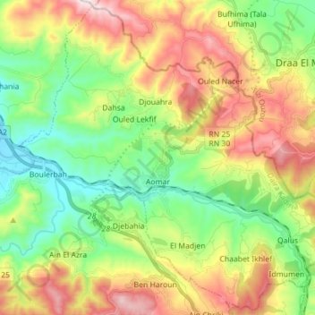
Name: Aomar topographic map, elevation, terrain.
Location: Aomar, Kadiria District, Bouira, Algeria (36.44640 3.70942 36.55560 3.84993)
Average elevation: 438 m
Minimum elevation: 166 m
Maximum elevation: 848 m
Thank you for supporting this site ❤️
Make a donation
Make a donation
Gear up for your next adventure:
As an Amazon Associate, this site earns from qualifying purchases at no extra cost to you.
Other topographic maps
Click on a map to view its topography, its elevation and its terrain.