
Make a donation
Gear up for your next adventure:
As an Amazon Associate, this site earns from qualifying purchases at no extra cost to you.
Joe Morolong Local Municipality topographic map
Click on the map to display elevation.
Make a donation
Gear up for your next adventure:
As an Amazon Associate, this site earns from qualifying purchases at no extra cost to you.
About this map
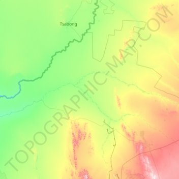
Name: Joe Morolong Local Municipality topographic map, elevation, terrain.
Average elevation: 1,074 m
Minimum elevation: 882 m
Maximum elevation: 1,802 m
Make a donation
Gear up for your next adventure:
As an Amazon Associate, this site earns from qualifying purchases at no extra cost to you.
Other topographic maps
Click on a map to view its topography, its elevation and its terrain.
Olifantshoek
South Africa > Northern Cape > John Taolo Gaetsewe District Municipality > Gamagara Local Municipality
Average elevation: 1,295 m
Kuruman
South Africa > Northern Cape > John Taolo Gaetsewe District Municipality > Ga-Segonyana Local Municipality
Average elevation: 1,335 m
Hotazel
South Africa > Northern Cape > John Taolo Gaetsewe District Municipality > Joe Morolong Local Municipality
Average elevation: 1,060 m
Mothibistad
South Africa > Northern Cape > John Taolo Gaetsewe District Municipality > Ga-Segonyana Local Municipality
Average elevation: 1,332 m
Make a donation
Gear up for your next adventure:
As an Amazon Associate, this site earns from qualifying purchases at no extra cost to you.
Gamagara
South Africa > Northern Cape > John Taolo Gaetsewe District Municipality
Average elevation: 1,178 m
Kathu
South Africa > Northern Cape > John Taolo Gaetsewe District Municipality > Gamagara Local Municipality
Average elevation: 1,223 m
Kuruman
South Africa > Northern Cape > John Taolo Gaetsewe District Municipality > Ga-Segonyana Local Municipality
Average elevation: 1,335 m
Olifantshoek
South Africa > Northern Cape > John Taolo Gaetsewe District Municipality > Gamagara Local Municipality
Average elevation: 1,295 m
Make a donation
Gear up for your next adventure:
As an Amazon Associate, this site earns from qualifying purchases at no extra cost to you.
Kathu
South Africa > Northern Cape > John Taolo Gaetsewe District Municipality > Gamagara Local Municipality
Average elevation: 1,223 m
Hotazel
South Africa > Northern Cape > John Taolo Gaetsewe District Municipality > Joe Morolong Local Municipality
Average elevation: 1,060 m
Dithakong
South Africa > Northern Cape > John Taolo Gaetsewe District Municipality > Joe Morolong Local Municipality
Average elevation: 1,265 m
Mothibistad
South Africa > Northern Cape > John Taolo Gaetsewe District Municipality > Ga-Segonyana Local Municipality
Average elevation: 1,332 m
Make a donation
Gear up for your next adventure:
As an Amazon Associate, this site earns from qualifying purchases at no extra cost to you.