
Make a donation
Gear up for your next adventure:
As an Amazon Associate, this site earns from qualifying purchases at no extra cost to you.
Mount Finlayson topographic map
Click on the map to display elevation.
Make a donation
Gear up for your next adventure:
As an Amazon Associate, this site earns from qualifying purchases at no extra cost to you.
About this map
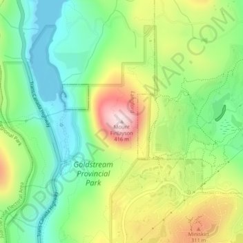
Name: Mount Finlayson topographic map, elevation, terrain.
Average elevation: 158 m
Minimum elevation: 0 m
Maximum elevation: 408 m
Make a donation
Gear up for your next adventure:
As an Amazon Associate, this site earns from qualifying purchases at no extra cost to you.
Other topographic maps
Click on a map to view its topography, its elevation and its terrain.
Goldstream Provincial Park
Canada > British Columbia > Capital Regional District > Langford
Average elevation: 178 m
Langford Lake
Canada > British Columbia > Capital Regional District > Langford
Average elevation: 105 m
Florence Lake
Canada > British Columbia > Capital Regional District > Langford
Average elevation: 121 m
Florence Lake
Canada > British Columbia > Capital Regional District > Langford
Average elevation: 121 m
Make a donation
Gear up for your next adventure:
As an Amazon Associate, this site earns from qualifying purchases at no extra cost to you.