Geolocate

St. Austell topographic map

Click on the map to display elevation.

About this map
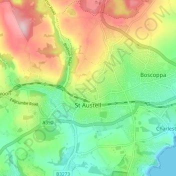
Name: St. Austell topographic map, elevation, terrain.

Location: St. Austell, Cornwall, England, United Kingdom (50.32947 -4.81398 50.35535 -4.74967)

Average elevation: 104 m

Minimum elevation: 0 m

Maximum elevation: 262 m

Other topographic maps

Click on a map to view its topography, its elevation and its terrain.
Port Isaac

United Kingdom > England > Cornwall

Average elevation: 43 m

Gunnislake

United Kingdom > England > Cornwall

Average elevation: 109 m

Darite

United Kingdom > England > Cornwall > St Cleer

Average elevation: 236 m

Pengold

United Kingdom > England > Cornwall > St Gennys

Average elevation: 135 m

Bridgetown

United Kingdom > England > Cornwall

Average elevation: 93 m

Gear up for your next adventure:

🎒40L Day Hiking Backpacks - Comfortable packs with hydration support for long days exploring topographic peaks
🦯Trekking Poles - Walking poles for hiking stability
🧣Merino Neck Gaiters - Versatile headwear for warmth, sun protection, or dust filtering
👖Convertible Hiking Trousers - Zip-off legs to adapt to changing temperatures throughout the day
📟Satellite Messengers - Two-way satellite communication to stay in touch beyond the cellular grid

As an Amazon Associate, this site earns from qualifying purchases at no extra cost to you.