
Make a donation
Gear up for your next adventure:
As an Amazon Associate, this site earns from qualifying purchases at no extra cost to you.
Vik topographic map
Click on the map to display elevation.
Make a donation
Gear up for your next adventure:
As an Amazon Associate, this site earns from qualifying purchases at no extra cost to you.
Vik
Vík í Mýrdal is the warmest place in Iceland, with an annual mean temperature of 5.3 °C (41.5 °F). Like most of coastal Iceland, Vík í Mýrdal has a subpolar oceanic climate (Koppen Cfc) with cold but not severe winters, and cool, short summers. Its winters are among the warmest in Iceland, with an average winter day having a daytime high around 4 °C (39 °F). Because it lies on the windward side of the Gulf Stream, Vík í Mýrdal is the wettest coastal town in Iceland, with an annual rainfall of 2,250 millimetres (89 in), which is three times more than Reykjavík, five times more than Akureyri on the north coast of the island, and many times more than its far northern location would normally indicate. Precipitation on the Mýrdalsjökull and Vatnajökull glaciers near the town is believed to be as high as 4,100 millimetres (160 in) of rainfall equivalent, which would mean at least 49 metres (160 ft) of snow at those higher altitudes.
Make a donation
Gear up for your next adventure:
As an Amazon Associate, this site earns from qualifying purchases at no extra cost to you.
About this map
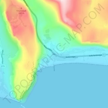
Name: Vik topographic map, elevation, terrain.
Location: Vik, Mýrdalshreppur, Southern Region, 870, Iceland (63.39882 -19.02547 63.43882 -18.98547)
Average elevation: 106 m
Minimum elevation: -3 m
Maximum elevation: 384 m
Make a donation
Gear up for your next adventure:
As an Amazon Associate, this site earns from qualifying purchases at no extra cost to you.
Other topographic maps
Click on a map to view its topography, its elevation and its terrain.