
Wallerode topographic map
Interactive map
Click on the map to display elevation.
About this map
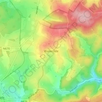
Name: Wallerode topographic map, elevation, terrain.
Location: Wallerode, Sankt Vith, Verviers, Luik, Wallonië, 4780, België (50.27870 6.13993 50.31870 6.17993)
Average elevation: 506 m
Minimum elevation: 428 m
Maximum elevation: 597 m
Other topographic maps
Click on a map to view its topography, its elevation and its terrain.
Eiterbach
België > Luik > Verviers > Sankt Vith
Eiterbach, Sankt Vith, Verviers, Luik, Wallonië, 4780, België
Average elevation: 496 m
Emmels
België > Luik > Verviers > Sankt Vith
Emmels, Sankt Vith, Verviers, Luik, Wallonië, 4780, België
Average elevation: 519 m
Oberst-Crombach
België > Luik > Verviers > Sankt Vith > Hinderhausen
Oberst-Crombach, Hinderhausen, Sankt Vith, Verviers, Luik, Wallonië, 4780, België
Average elevation: 530 m
Sankt Vith
België > Luik > Verviers > Sankt Vith
Sankt Vith, Verviers, Luik, Wallonië, 4780, België
Average elevation: 491 m
Alfersteg
België > Luik > Verviers > Sankt Vith > Schlierbach
Alfersteg, Schlierbach, Sankt Vith, Verviers, Luik, Wallonië, 4780, België
Average elevation: 469 m
Recht
België > Luik > Verviers > Sankt Vith
Recht, Sankt Vith, Verviers, Luik, Wallonië, 4780, België
Average elevation: 465 m