
Make a donation
Gear up for your next adventure:
As an Amazon Associate, this site earns from qualifying purchases at no extra cost to you.
Elbląg topographic map
Click on the map to display elevation.
Make a donation
Gear up for your next adventure:
As an Amazon Associate, this site earns from qualifying purchases at no extra cost to you.
Elbląg
The modern city adjoins about half the length of the river between Lake Drużno and Elbląg Bay (Zatoka Elbląska, an arm of the Vistula Lagoon), and spreads out on both banks, though mainly on the eastern side. To the east is the Elbląg Upland (Wysoczyzna Elbląska), a dome pushed up by glacial compression, 390 km2 in diameter and 200 m (656.17 ft) high at its greatest elevation.
Make a donation
Gear up for your next adventure:
As an Amazon Associate, this site earns from qualifying purchases at no extra cost to you.
About this map
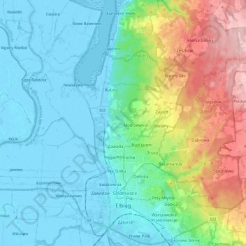
Name: Elbląg topographic map, elevation, terrain.
Location: Elbląg, Warmian-Masurian Voivodeship, Poland (54.13445 19.35901 54.26326 19.50969)
Average elevation: 49 m
Minimum elevation: -6 m
Maximum elevation: 193 m
Make a donation
Gear up for your next adventure:
As an Amazon Associate, this site earns from qualifying purchases at no extra cost to you.
Other topographic maps
Click on a map to view its topography, its elevation and its terrain.
Majewo-Kolonia
Poland > Warmian-Masurian Voivodeship > Elbląg County > Majewo
Average elevation: 142 m
Make a donation
Gear up for your next adventure:
As an Amazon Associate, this site earns from qualifying purchases at no extra cost to you.
Make a donation
Gear up for your next adventure:
As an Amazon Associate, this site earns from qualifying purchases at no extra cost to you.
Mrozy Małe
Poland > Warmian-Masurian Voivodeship > Ełk County > Mrozy Wielkie > Mrozy Małe
Average elevation: 127 m