
Salto topographic map
Interactive map
Click on the map to display elevation.
About this map
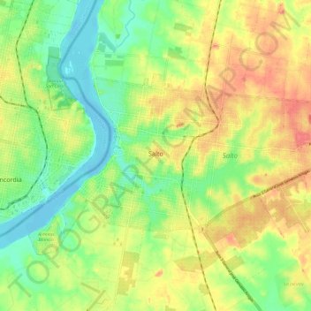
Name: Salto topographic map, elevation, terrain.
Location: Salto, 50000, Uruguay (-31.41614 -57.99652 -31.36290 -57.87885)
Average elevation: 34 m
Minimum elevation: -3 m
Maximum elevation: 74 m
Built on hills and bluffs, the city is situated near the Rio Uruguay's 'big jump' falls, which is also the location of the Salto Grande Dam.[2] The land is low lying alongside the river bank, with an elevation of 48 metres (157 ft) above sea level.