
Castleknock topographic map
Click on the map to display elevation.
Castleknock
As the word Castle did not come into use in Ireland until Norman times we know that Castleknock is a name of comparatively recent origin. Documents from the 12th and 13th centuries refer to the place as Castrum Cnoc, simply Cnoc and also Chastel-cnoc or Castel-Cnoc.[8] So it seems that the name Castleknock is rooted in the topography of the hill or cnoc located at the centre of the modern neighbourhood and/or the personal name of the mother of a semi-legendary High King i.e. Cnucha and the building of a castle by Normans on this site in the 12th century.
About this map
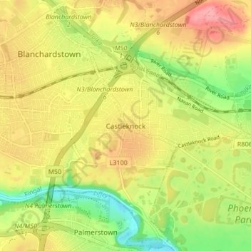
Name: Castleknock topographic map, elevation, terrain.
Average elevation: 55 m
Minimum elevation: 7 m
Maximum elevation: 98 m
Other topographic maps
Click on a map to view its topography, its elevation and its terrain.