
Make a donation
Gear up for your next adventure:
As an Amazon Associate, this site earns from qualifying purchases at no extra cost to you.
Miami topographic map
Click on the map to display elevation.
Make a donation
Gear up for your next adventure:
As an Amazon Associate, this site earns from qualifying purchases at no extra cost to you.
Miami
Miami and its suburbs are located on a broad plain between the Everglades to the west and Biscayne Bay to the east, which extends from Lake Okeechobee southward to Florida Bay. The elevation of the area averages at around 6 ft (1.8 m) above sea level in most neighborhoods, especially near the coast. The highest points are found along the Miami Rock Ridge, which lies under most of the eastern Miami metro. The main portion of the city is on the shores of Biscayne Bay, which contains several hundred natural and artificial barrier islands, the largest of which contains Miami Beach and South Beach. The Gulf Stream, a warm ocean current, runs northward just 15 miles (24 km) off the coast, allowing the city's climate to stay warm and mild all year.
Make a donation
Gear up for your next adventure:
As an Amazon Associate, this site earns from qualifying purchases at no extra cost to you.
About this map
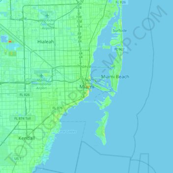
Name: Miami topographic map, elevation, terrain.
Location: Miami, Miami-Dade County, Florida, 33131, United States (25.61417 -80.35362 25.93417 -80.03362)
Average elevation: 4 m
Minimum elevation: -2 m
Maximum elevation: 43 m
Make a donation
Gear up for your next adventure:
As an Amazon Associate, this site earns from qualifying purchases at no extra cost to you.
Other topographic maps
Click on a map to view its topography, its elevation and its terrain.
Florida City
United States > Florida > Miami-Dade County
Florida City is situated mostly atop a limestone ridge called the Miami Rock Ridge that extends south from present day North Miami Beach to a location in Everglades National Park. The ridge, consisting of Miami limestone, serves as the higher ground within the community. The ridge extended from northeast to…
Average elevation: 3 m
Make a donation
Gear up for your next adventure:
As an Amazon Associate, this site earns from qualifying purchases at no extra cost to you.
Make a donation
Gear up for your next adventure:
As an Amazon Associate, this site earns from qualifying purchases at no extra cost to you.
Alice C Wainwright Park
United States > Florida > Miami-Dade County > Miami > Brickell Hammock
Average elevation: 6 m
Make a donation
Gear up for your next adventure:
As an Amazon Associate, this site earns from qualifying purchases at no extra cost to you.
Make a donation
Gear up for your next adventure:
As an Amazon Associate, this site earns from qualifying purchases at no extra cost to you.
Make a donation
Gear up for your next adventure:
As an Amazon Associate, this site earns from qualifying purchases at no extra cost to you.
Tamiami
United States > Florida > Miami-Dade County > University Lakes Mobile Home Park
Average elevation: 6 m
Make a donation
Gear up for your next adventure:
As an Amazon Associate, this site earns from qualifying purchases at no extra cost to you.
Burke Recreation Center
United States > Florida > Miami-Dade County > Biscayne Park
Average elevation: 9 m
Richmond Heights
United States > Florida > Miami-Dade County > Richmond Heights
Average elevation: 6 m
Make a donation
Gear up for your next adventure:
As an Amazon Associate, this site earns from qualifying purchases at no extra cost to you.
Make a donation
Gear up for your next adventure:
As an Amazon Associate, this site earns from qualifying purchases at no extra cost to you.
South Miami Heights
United States > Florida > Miami-Dade County > South Miami Heights
Average elevation: 6 m
Make a donation
Gear up for your next adventure:
As an Amazon Associate, this site earns from qualifying purchases at no extra cost to you.