
Make a donation
Gear up for your next adventure:
As an Amazon Associate, this site earns from qualifying purchases at no extra cost to you.
Orgen topographic map
Click on the map to display elevation.
Make a donation
Gear up for your next adventure:
As an Amazon Associate, this site earns from qualifying purchases at no extra cost to you.
About this map
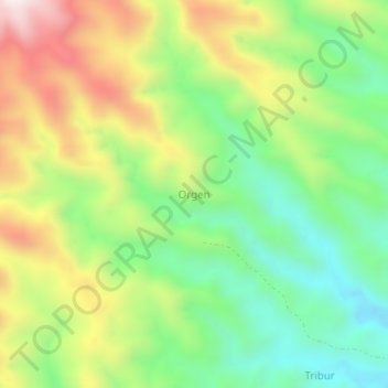
Name: Orgen topographic map, elevation, terrain.
Average elevation: 397 m
Minimum elevation: 78 m
Maximum elevation: 861 m
Make a donation
Gear up for your next adventure:
As an Amazon Associate, this site earns from qualifying purchases at no extra cost to you.
Other topographic maps
Click on a map to view its topography, its elevation and its terrain.
Pantar Island
Indonesia > East Nusa Tenggara > Alor
The island consists of two distinct geographic zones. The eastern zone is dominated by a range of verdant hills which drop steeply to the coast of the Alor Strait. The western zone is relatively flat, consisting of a plain which gently slopes to the west from Mount Sirung, an 862-metre-high (2,828-foot) active…
Average elevation: 98 m