
Seven Devils topographic map
Click on the map to display elevation.
About this map
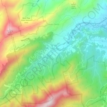
Name: Seven Devils topographic map, elevation, terrain.
Location: Seven Devils, Watauga County, North Carolina, United States (36.11835 -81.83952 36.16695 -81.78408)
Average elevation: 1,175 m
Minimum elevation: 913 m
Maximum elevation: 1,589 m
Other topographic maps
Click on a map to view its topography, its elevation and its terrain.
Valle Crucis
United States > North Carolina > Watauga County
Valle Crucis is located at the banks of Dutch Creek and Watauga River, at an elevation of 2,677 feet (816 m) above sea level. To its north and east is Tester Mountain and to its south and west is Valle Mountain. The community is also within the Pisgah National Forest boundary, which limits some development in…
Average elevation: 904 m
Beech Mountain
United States > North Carolina > Watauga County > Beech Mountain
Average elevation: 1,264 m
Rich Mountain
United States > North Carolina > Watauga County
Rich Mountain is a mountain located in the North Carolina High Country, roughly 3 miles (4.8 km) northwest of the town of Boone. Its elevation reaches 4,748 feet (1,447 m).
Average elevation: 1,214 m
Buckeye Lake
United States > North Carolina > Watauga County > Beech Mountain
Average elevation: 1,160 m
Elk Knob
United States > North Carolina > Watauga County
Elk Knob is a mountain in the North Carolina High Country, north of the community of Meat Camp. Its elevation reaches 5,538 feet (1,688 m).
Average elevation: 1,362 m
Rich Mountain
United States > North Carolina > Watauga County
Rich Mountain is a mountain located in the North Carolina High Country, roughly 3 miles (4.8 km) northwest of the town of Boone. Its elevation reaches 4,748 feet (1,447 m).
Average elevation: 1,214 m
Appalachian Ski Mountain Dam
United States > North Carolina > Watauga County
Average elevation: 1,113 m
Boone
United States > North Carolina > Watauga County > Boone > Boone
Boone is located at 36°12′41″N 81°40′7″W / 36.21139°N 81.66861°W / 36.21139; -81.66861 (36.211364, −81.668657) and has an elevation of 3,333 feet (1015.9 m) above sea level. An earlier survey gave the elevation as 3,332 ft and since then it has been published as having an elevation of…
Average elevation: 977 m
Sorrento Skies
United States > North Carolina > Watauga County > Sorrento Skies
Average elevation: 1,069 m