
Rezekne topographic map
Interactive map
Click on the map to display elevation.
About this map
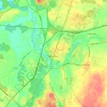
Name: Rezekne topographic map, elevation, terrain.
Location: Rezekne, Latgale, Latvia (56.47773 27.30322 56.53809 27.37954)
Average elevation: 148 m
Minimum elevation: 119 m
Maximum elevation: 183 m
Other topographic maps
Click on a map to view its topography, its elevation and its terrain.
Bindari
Latvia > Latgale > Preiļu novads
Bindari, Preiļu novads, Latgale, LV-5326, Latvia
Average elevation: 126 m
Purpļi
Latvia > Latgale > Krāslavas novads > Dagdas pagasts
Purpļi, Dagdas pagasts, Krāslavas novads, Latgale, LV-5674, Latvia
Average elevation: 176 m
Černoste
Latvia > Latgale > Rēzeknes novads
Černoste, Rēzeknes novads, Latgale, Latvia
Average elevation: 165 m
Viļakas pilsētas pludmale
Latvia > Latgale > Balvu novads > Viļaka
Viļakas pilsētas pludmale, Viļaka, Balvu novads, Latgale, Latvia
Average elevation: 95 m
Saulkrasti
Latvia > Latgale > Saulkrasti
Saulkrasti, Krāslavas novads, Latgale, Latvia
Average elevation: 132 m