
Fachbach topographic map
Interactive map
Click on the map to display elevation.
About this map
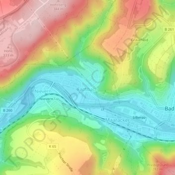
Name: Fachbach topographic map, elevation, terrain.
Average elevation: 192 m
Minimum elevation: 69 m
Maximum elevation: 346 m
Other topographic maps
Click on a map to view its topography, its elevation and its terrain.
Lahn
Deutschland > Rheinland-Pfalz > Rhein-Lahn-Kreis > Fachbach > Auf der Oberau
Lahn, Auf der Oberau, Fachbach, Bad Ems-Nassau, Rhein-Lahn-Kreis, Rheinland-Pfalz, 56133, Deutschland
Average elevation: 210 m
Lahn
Deutschland > Rheinland-Pfalz > Rhein-Lahn-Kreis > Fachbach > Auf der Oberau
Lahn, Auf der Oberau, Fachbach, Bad Ems-Nassau, Rhein-Lahn-Kreis, Rheinland-Pfalz, 56133, Deutschland
Average elevation: 214 m